 Nederlands
 Dansk
Dansk Österreichisch
 Po Polsku


The departmental communities Grünewald/Sella past and present
Grünewald/Sella is situated in the landscape protection area Elster lowland and west of the Oberlausitzer Heath, between Senftenberg and Ortrand.
5km distance to the Buckschen Schweiz,
15km distance to the Senftenberger Lake and
6km distance to the rhododendron garden in Grüngräbchen (Saxony).
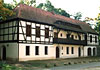
Cycle and hiking paths run from Grüngräbchen via Sella to Hohenbocka. Sella is the touristy quiet point. Belfry in Sella, stork nests and war memorial in both villages. The oldest building is situated in Grünewald, a thatched barn.

The village Grünewald/Sella is a rural comminity situated southeast of Ruhland. It consists of two villages, Grünewald-wendisch-Zeleny-Hozdz = Grüner Wald (green forest)and Sella-wendisch Zelnje = Schildkrötensumpf (turtle swamp). Both villages belonged in the course of development to Prussia, Saxony and Lower Silesia, today to the state Brandenburg. The community is located in the district Oberspreewald-Lausitz and is allocated since 1992 to Amt Ruhland. The community borders in the south and east onto the Free State of Saxony. Neighbouring villages are Guteborn, Hohenbocka, Wiednitz, Grüngräbchen and Cosel.
The village Sella was in the year 1938 incorporated after Grünewald. Sella was first mentioned in 1523 and Grünewald in 1529 and celebrated in 1979 its 450 year existence. Both villages are in their settlement centre Slavic round villages with partly attached street village.
209 people lived in 1825 in Grünewald and in Sella 110 people.
Both villages had in 1946 a population of 919 and 709 citizens lived in 1999 in both villages whereby 584 citizens fall to Grünewald and 125 to Sella.


")


